Bank
North Gate
South-east gate
South-west gate
Palisades
Feature Befund 392
Sunset on Beltane
Passage SE
Passage N
Sunset SSS
Sunrise SSS
Beltane sunrise
Observation point for astronomical events
The circular ditch
.")
Zoom
Info
Excavation plan of the Goseck circular ditched enclosure with colour highlighting of the Stroke-ornamented Pottery features (orange). Plan: A. Northe, adapted by N. Henkel.
The earthen bank

The reconstructed circular ditched enclosure at Goseck with external earthen bank. © LDA, photo: J. Lipták.
Text The earthen bank
One of the main questions of the excavations was the whereabouts of the earthen material that had accumulated during the excavation of the ditch. The evaluation of the ditch sections provided several indications of asymmetric filling layers, which are interpreted as excavated spoil that was secondarily washed back into the ditch.
F. Bertemes therefore assumes that the excavated earth from the ditch had been heaped up as a low mound of earth in front of the ditch, some of which subsequently slid back into the ditch. The possibility that the earthen material had been heaped up between the ditch and the palisade circles, as for a long time supposed for Svodín (Slovakia), for example, could be safely disproved on the basis of the numerous pit features in this area.
For Goseck it thus seemed proven that the excavated earth from the trenching was not transported away from the site and stored or levelled elsewhere, but was used for the construction of the site.
The most recent findings concerning the question of the existence and construction of an earthwork in front of the ditch stem from Norma Henkel. In her dissertation, she comes to the conclusion that the bank cannot be verified in its entirety, but should rather be reconstructed as a segmented earthen bank.
This is supported by, among other things, several pits of the Stroke-ornamented Pottery Culture (features Befund 129, 460, 471) which lie exactly in the area of the presumed earthwork. At least in these areas, no bank could have existed at the time of the circular ditched enclosure.
What is fascinating is that an embankment lying in front of the ditch has less defensive effect: Attackers would not have to scale the longer scarp of the construction from the bottom of the ditch, but could just run down from the embankment and then only have to climb out of the ditch. Was the embankment perhaps intended more symbolically to prevent anything from escaping from the enclosure?
Since the earthen bank was only indirectly verifiable, no absolute measurements are available. Based on the size of the ditch, the height of the earthen bank can be reconstructed as 1.5 to 2.5 metres with a width of 3 to 5 metres.

The northern gate
Feature 192-04, 193-04

Unlike the two southern gates, no clear astronomical reference could be identified for the northern gate. Furthermore, the position of the northern gate deviates slightly from the direction of geographic north.
Especially in the fill of the eastern gate jamb large quantities of animal bones and pottery came to light, including special pieces that stand out from the rest of the find material due to their quality and decoration. Further special findings are horn cones and other bone fragments not only from domestic cattle but also from aurochs.
 of the north gate in planum.")
 of the north gate in planum.")
South-east gate (features 123-03, 124-03)
Text South-east gate (features Befund 123-03, 124-03)
The south-eastern gate of the circular ditch was aligned to the sunrise on winter solstice: If one stood in the middle of the enclosure on the morning of 21 December, the rays of the rising sun fell exactly through the south-eastern gate. Sunset could be observed via the line of sight through the south-western gate.


Die Torwangen des Südost-Tores im Planum. Aufnahme von Osten. © LDA, Foto: A. Northe 2003.

Das Südosttor im Luftbild. Aufnahme von Osten. © LDA, Foto: A. Northe 2003.
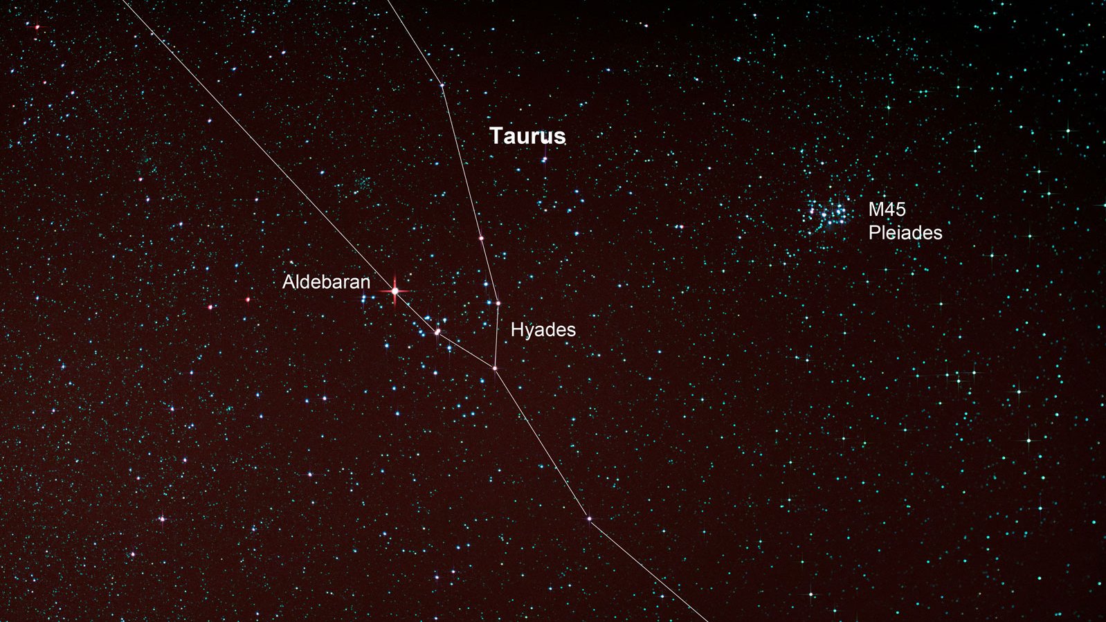
[Translate to English:] Astronomischer Bezug zum Sternbild Stier
(Kopie 16)
[Translate to English:]
Um 4800 v.Chr. war im Bereich des Südosttores außerdem der Sternhaufen der Hyaden mit bloßem Auge gut zu beobachten. Die Hyaden, auch Regengestirn genannt, sind von September bis April am nördlichen Sternenhimmel sichtbar. Ihr Erscheinen im Herbst kündigt den Beginn der feucht-kalten Jahreszeit und der Herbsttürme an. Die Hyaden gehören zum Sternbild Stier und bilden mit ihrer V-förmigen Formation den Kopf des Stieres. Dieser astronomische Bezug scheint insbesondere wegen der zahlreichen Funde von Rinderschädeln im Kreisgraben von großer Bedeutung zu sein.
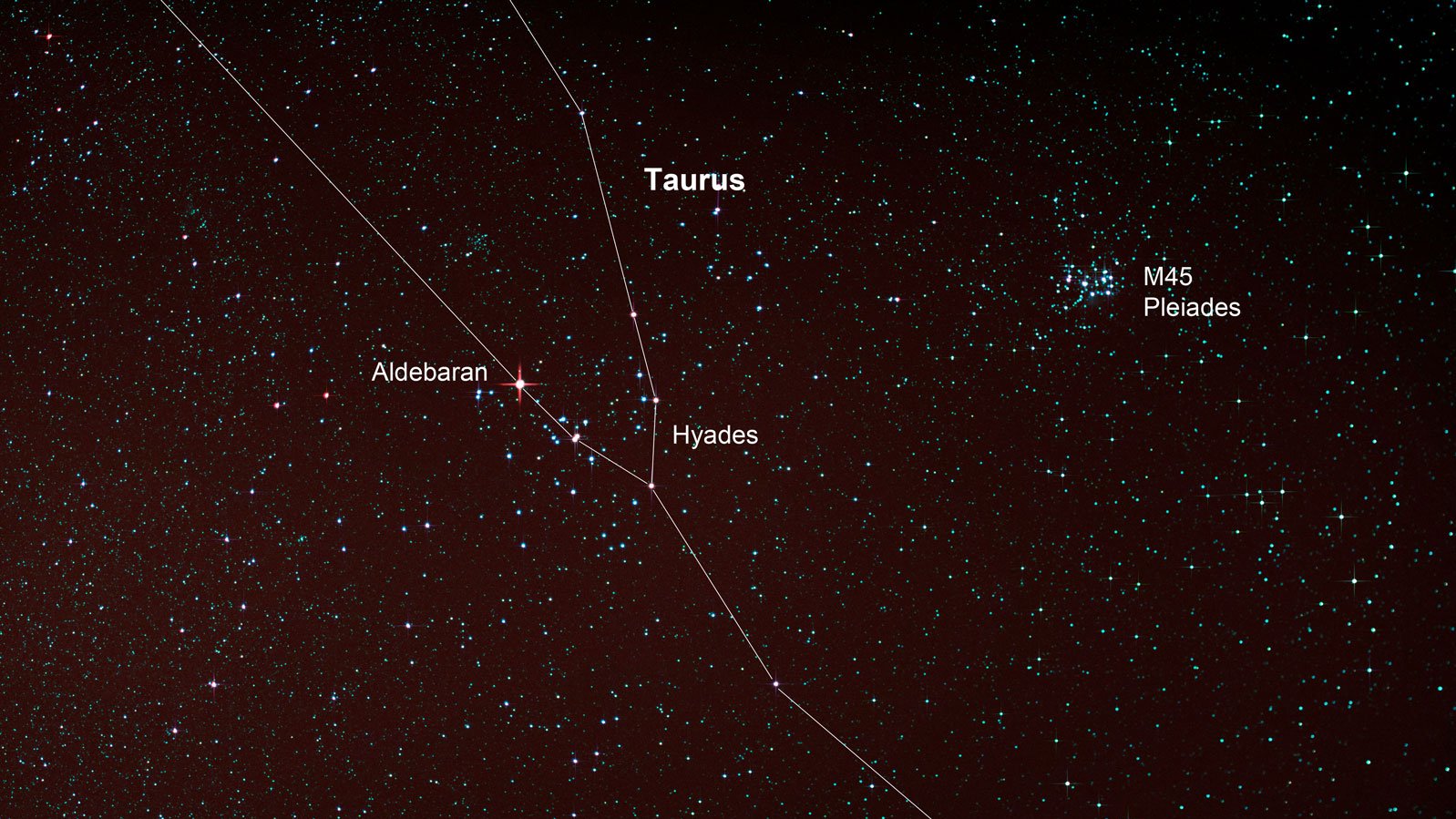
Sternbild Stier mit den Hyaden und dem rot leuchtenden Aldebaran. Im Hintergrund rechts sind die Plejaden zu sehen. ©3quarks/iStockphoto.com.
South-west gate (features Befund 417-04, 386-04)
![[Translate to English:] Sonnenuntergang zur Wintersonnenwende](/fileadmin/media/goseck/Fotos_Rekonstruktion/wsw_sw_tor_2006_goseck_1200x1600-schlosser-bertemes.jpg "[Translate to English:] Sonnenuntergang zur Wintersonnenwende")
[Translate to English:] Sonnenuntergang zur Wintersonnenwende. Foto: F. Bertemes.
Text South-west gate (features Befund 417-04, 386-04)
The gate in the south-west of the circular ditch also corresponds with solar observation points of the winter solstice. From the centre of the enclosure, the last rays of the setting sun fall through the gate jambs on winter solstice 21 December. In the area of the northern gate jamb (feature Befund 386/04), a particularly large number of animal bones were found, including horn cones and horn cone fragments from cattle.
![[Translate to English:] Planum der nördlichen Torwange (Bef. 386/04). © LDA, Foto: A. Northe.](/fileadmin/media/goseck/befunde/bef-386-graben-durchlass-sw_1200x800.jpg "[Translate to English:] Planum der nördlichen Torwange (Bef. 386/04). © LDA, Foto: A. Northe.")
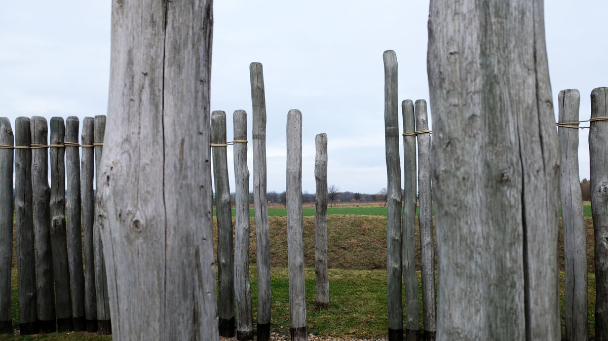
The two palisade rings
[Translate to English:] Blick durch die innere Palisade in den Innenraum der Kreisgrabenanlage. © LDA, Foto: D. Wollenberg.
(Kopie 23)
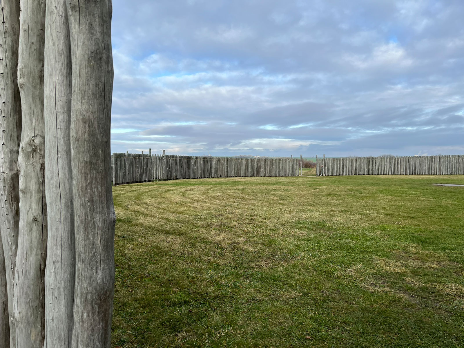
Two concentric palisade rings delimit the inner area of the enclosure from the outside. 1758 wooden posts were sunk into the ground for the reconstruction of both palisades. For this purpose, first a foundation trench was dug and then the unpointed posts were inserted. The timbers were placed so close together that they created a largely impenetrable wall. In the course of the excavations, however, it became apparent that the palisades were deliberately interrupted at several points.
[Translate to English:] Astronomische Bezüge
[Translate to English:]
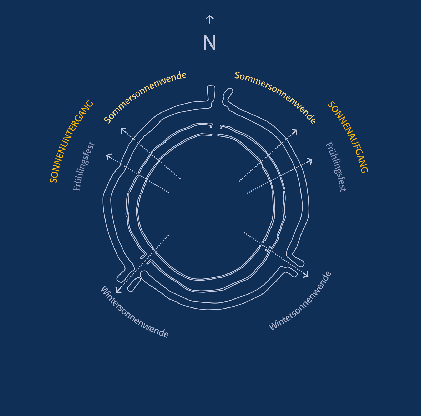
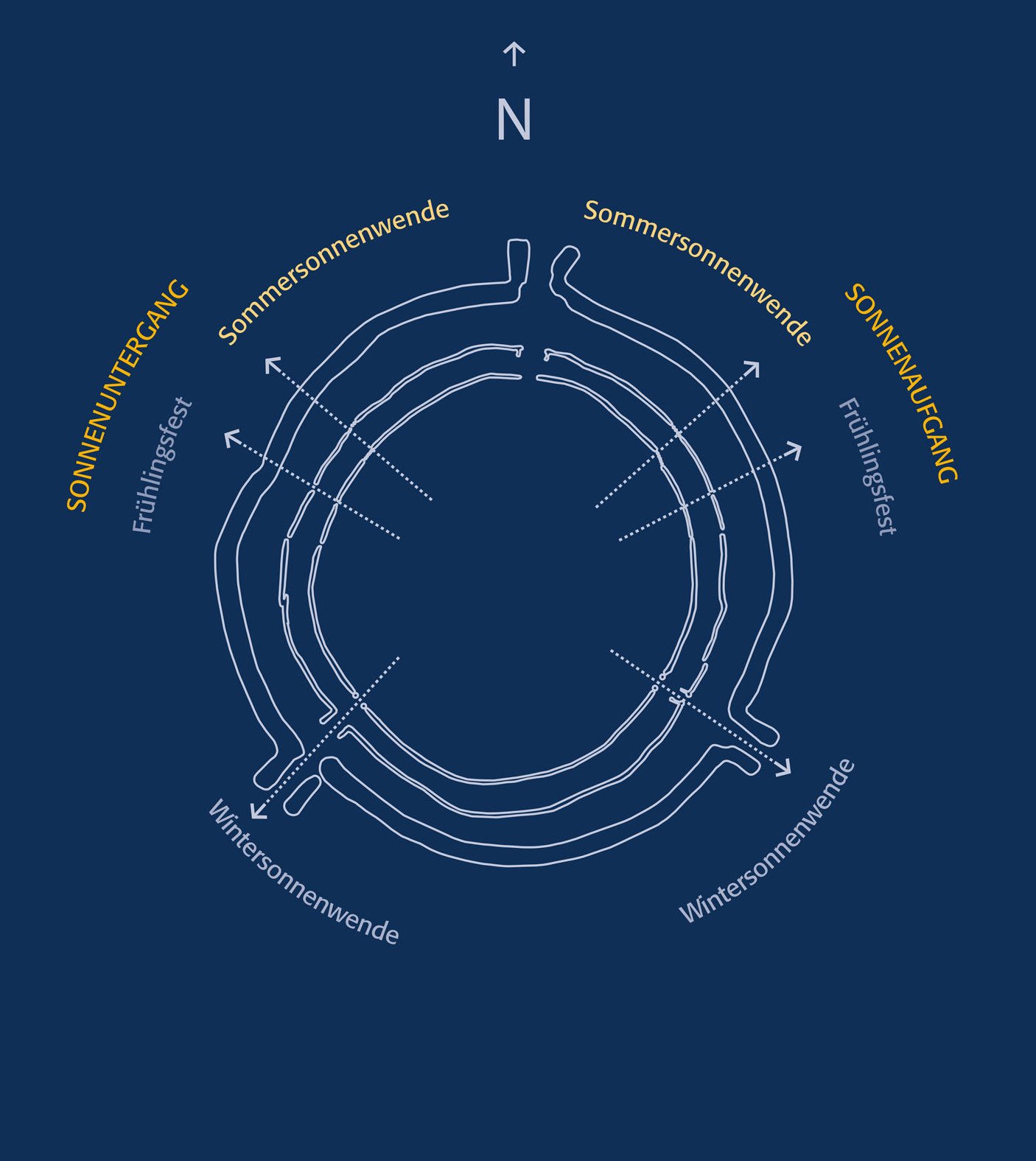
Beide Palisaden weisen an drei Stellen Durchlässe auf, die mit den Toren des Kreisgrabens übereinstimmen (Norden, Südosten, Südwesten). Vor den Durchlässen wurde jeweils ein mächtiger Einzelpfosten eingesetzt. Weitere Durchlässe in den Palisaden sind außerdem im Nordwesten und Nordosten sowie im Bereich der Sonderbestattung (Befund 139) dokumentiert worden. Bis auf das nördliche Tor sind alle Durchlässe auf Beobachtungspunkte astronomischer Ereignisse ausgerichtet.
[Translate to English:] Die astronomischen Bezüge der Kreisgrabenanlage von Goseck. © xxx ergänzen.
Pit with traces of fire
![[Translate to English:] Grubenbefund 392 im Profil.](/fileadmin/media/goseck/befunde/bef-392-profil-montage-1600x1200.jpg "[Translate to English:] Grubenbefund 392 im Profil. © LDA, Foto: A. Northe, Zeichnung: J. Möhwald, R. Ranlin.")
[Translate to English:] Grubenbefund 392 im Profil. Gut erkennbar sind die fast schwarzen Spuren von Feuer, die hier vor knapp 7000 Jahren brannten. In der Grube wurden über einen längeren Zeitraum immer wieder Feuer entfacht. © LDA, Foto: A. Northe, Zeichnung: J. Möhwald, R. Ranlin.
Opening through the palisades in the north-west
Text Opening through the palisades in the north-west
At this point the otherwise largely gapless palisade is interrupted. The narrow opening in both palisades in the north-west is aligned towards the sunset on Beltane (1 May).
![[Translate to English:] Der Palisadendurchlass im Nordwesten mit Ausrichtung auf den Sonnenuntergang zu Beltaine](/fileadmin/media/goseck/Fotos_Rekonstruktion/nw-durchlass-beltaine-05.jpg "[Translate to English:] Der Palisadendurchlass im Nordwesten mit Ausrichtung auf den Sonnenuntergang zu Beltaine.")
South-eastern passage
Text South-eastern passage
The opening in the inner palisade ring was only 60 cm wide and accentuated on both sides by a massive single post. At 80 cm the opening in the outer ring was slightly wider. Similar to the circular ditch, the passage here was provided with gate jambs, which, however, did not point outwards but towards the interior of the enclosure.

South-eastern passage in the palisades to the interior of the circular ditched enclosure. © LDA, photo: D. Wollenberg.
 of the outer palisade at the south-eastern passage.")
Passage in the north
Similar to the palisade openings in the south-east, gaps and a gate situation could also be observed in the north. The width of the opening in the area of the outer palisade of over three metres is striking. It is interesting to note here that the passage is not oriented exactly to the north. An astronomical alignment is not known.
Further passages in the south-east can be assumed, in analogy to the circular ditch, also in the palisades. Due to the poor preservation of the features in this area of the excavation, however, they could no longer be detected.
![[Translate to English:] Nördlicher Durchlass im Bereich der Palisaden](/fileadmin/media/goseck/Fotos_Rekonstruktion/durchlass-nord-inne_und_aussenpalisade_1200x900.jpg "Northern opening of the inner and outer palisade. © LDA, photo: D. Wollenberg.")


Summer solstice sunset
Text Summer solstice sunset
In a section of the inner palisade, five loosely placed posts (features Befund 183, 184, 185, 186, 187) form an optical opening of about 1.5 m. The outer palisade also has an opening of approx. 1.9 m in this area. The opening in the outer palisade is formed by four posts (features Befund 188, 189, 359, 358), which were placed at clear distances from each other. From the centre of the circular ditched enclosure, the sunset on the evening of summer solstice (21 June) could be observed through these two gaps in the palisade.


Summer solstice sunrise
Text Summer solstice sunrise
In the north-east, the inner palisade is interrupted exactly where the sunrise could be observed on the horizon on the day of the summer solstice. Due to poor preservation, an analogous interruption of the outer palisade could not be recorded. However, two post pits were observed between the inner and outer palisade, which also run in the line of sight described above. These may have been posts used for finding the position of the sunrise on summer solstice.
[Translate to English:] Blick durch die Palisadenöffnungen im Nordosten der rekonstruierten Anlage. © LDA, Foto: D. Wollenberg.

[Translate to English:] Die beiden Pfostengruben Bef. 257, 258 liegen auf der Visurlinie des Sonnenaufgangs zur Sommersonnenwende. © LDA, Foto: Andreas Northe.
Beltane sunrise
Text Beltane sunrise
Another passage in both palisades is exactly aligned with the sunrise on Beltane (1 May). On the opposite side of the enclosure, mirrored in the same place, a passage can be found in the line of sight of the sunset on Beltane.

The passage in the outer palisade is aligned to the sunrise on Beltane. © LDA, photo: D. Wollenberg.
.")
Observation point for astronomical events
(Kopie 61)
The central observation point, from which all important solar events were visible, is not the geometrical centre of the site. The observation point is slightly offset to the north-west. From this location, the sunrises and sunsets of important astronomical events could be predicted and observed to within a few days. The most important lines of sight run through the two openings in the south-east and south-west. Only here are the gaps in the palisades also mirrored in the circular ditch. They correspond with the rising and setting points of the sun on winter solstice (21 December). Other openings in the palisades are aligned to summer solstice (21 June) and Beltane (30 April).
The circular ditch
(Kopie 63)
With a maximum diameter of 75 m the circular ditch is one of the smaller of its kind. It is a V-shaped ditch about 2 m wide, which was still visible as an infilled ditch from ground level down to a depth of 1.80 m.

(Kopie 65)
The excavations showed that the ditch had been constructed in segments. This means that individual sections of the ditch were excavated and eventually joined together. This can be seen, for example, in the strongly varying depths of the bottom of the ditch. The complex could be entered via three entrances, one each in the north, south-east, and south-west. These entrances were designed as gates. The two southern gates were aligned exactly with the sun's rising and setting points on the horizon on winter solstice.
Within the ditch fill, three infilling horizons can be distinguished, which are associated with different phases of use of the site: The primary period of use of the circular ditched complex spanned the period between 4900/4850 to 4700 BC. During this time the ditch was repeatedly partially infilled, cleaned, and restored. From around 4700/4650 BC the ditch was left open. Sediment deposited by wind and rain collected at the bottom of the ditch. Shortly afterwards, around 4650/4550 BC, the ditch was finally backfilled.